Following the Lewis and Clark Trail
Updated Oct. 10, 2003
August 10, 2003
Nancy and I are planning to be "on the road" again in our Roadtrek. We hope to be underway on Wednesday, Aug. 13. Our plans are to "follow" the route taken by Meriwether Lewis and William Clark from St. Louis, MO to the Pacific Ocean.
Thomas Jefferson commissioned Lewis and Clark to (1) investigate the lands acquired from the French as part of the Louisiana Purchase, (2) follow the Missouri River to its source, and (3) to determine if there is a Northwest Passage to the Pacific Ocean. Lewis and Clark left St. Louis in May 1804 and headed up the Missouri river. They followed it to where it is formed by the confluence of three rivers, which they named the Jefferson, Gallatin, and Madison rivers. They went up the Jefferson River and and then the Beaverhead River until it was no longer navigable by boat. After acquiring horses from the Shoshone, they crossed the Rocky Mountains to the Clearwater River in Idaho. Here they switched back to canoes and went down the Clearwater to the Snake and finally the Columbia River, arriving at the Pacific Ocean in November, 1805.
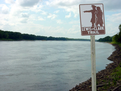
The Missouri River upstream from St. Charles, MO
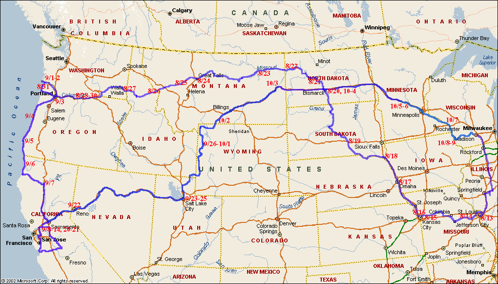
Planned Route
Our planned route is to first head south to St. Louis, with a detour to Mt. Auburn, IL, where my great grandfather, Valentine, lived and my grandfather, Jonathan, was born. We will then visit our son Dan in St. Louis before heading out on the Lewis and Clark trail. We plan to drive along the Missouri river (as much as is reasonable) to Great Falls, MN, stopping at various sites of importance in the Lewis and Clark journey. Last year we followed the Lewis and Clark trail from Great Falls to Lolo pass in Idaho, so this year we will head straight for Lolo pass from Great Falls and then follow the trail again to Astoria, OR, on the Pacific coast. The map below (click on the icon to see it) shows our planned route to Oregon. From there we will head down the Oregon coast and into California to visit family. In late September we will head back to Wisconsin by a more direct route.
 Where
are we now? And where are we going? If you want to know, click on the "thumbnail" to the left to see
the full map of our planned route to Oregon, where we have camped, and our current location.
Where
are we now? And where are we going? If you want to know, click on the "thumbnail" to the left to see
the full map of our planned route to Oregon, where we have camped, and our current location.
We hope to make the trip somewhat faster than Lewis and Clark. We are planning on taking about a month to get to the Pacific Ocean, rather than 18 months they took. If we get tired of following local roads along the rivers, we can always opt for taking the interstate highways; it won't be as scenic or true to history, but is easier driving.
Photos and Experiences in Route
We plan to upload pictures and a "diary" of our experiences as we make this journey. The frequency of updating the web site will depend on availability of access to the Internet and having something worthwhile to show or write about.
Since we are now home, this journey is complete. There will be no more additions to this web page.