
Following the Missouri River to the Kansas River
Aug. 14 - 16, 2003
We started off on our Lewis and Clark adventure with a visit to the Lewis and Clark Interpretive Center in Hartford, IL. They have an excellent display about the Lewis and Clark expedition, focusing especially on the time at Camp Dubois (Dec. 1803 to May 2004). Lewis and Clark used this time to train the men they had enlisted and acquire final supplies.
Clark and the soldiers built log cabins in which to spend the winter at Camp Dubois. A reconstruction of Camp Dubois is being built at the Center.
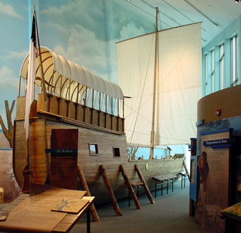
A replica of the keelboat that Lewis designed and had built for the
expedition.

After the Interpretive Center at Hartford, we crossed into Missouri to see the confluence of the Missouri and Mississippi rivers. This view is looking northeast. The Missouri is flowing in from the left and the Mississippi is entering behind the point and flowing out to the right. The present "Camp Dubois" is on the far shoreline. During the 200 years since the Lewis and Clark expedition, the Mississippi has shifted to the east, so the actual location of the original camp is believed to either underwater, or in Missouri, depending on which book you read.
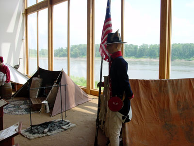
Lewis and the men departed Camp Dubois on May 14, 1804 and headed for St.
Charles, about 20 miles up the Missouri river. The Core of Discovery, as the
expeditionary force came to be known, camped at what is now Frontier park in St.
Charles until Lewis arrived; he had been in St. Louis on business. The Lewis and
Clark Center in St. Charles recreates this campsite in their museum. They also
have a keelboat and two pirogues (large canoes). We saw the pirogues, but the
keelboat is in Pittsburgh to start a float down the Ohio river on August 31. To
commemorate the bicentennial of the Lewis and Clark expedition, the keelboat and
pirogues will sail up the Missouri next May.
After St. Charles we headed along the Missouri River as far as Hermann, where we spent the night, and then headed for Arrow Rock State Historical Site where they have a nice museum on the Missouri Indians, but very little on Lewis and Clark. The next stop was Fort Osage near Independence, MO. Lewis and Clark noted that the terrain at this location would be excellent for a fort and trading post, and so Clark started construction of the fort in about 1808.
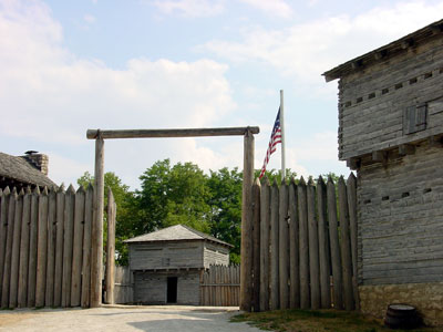
The reconstructed Fort Osage on the Missouri River northeast of Independence,
MO. It is on the actual location of the original fort, and follows the plans
that Clark had drawn up.

This interpreter working in the fort certainly loved to tell stories of the
history of the fort and the area.
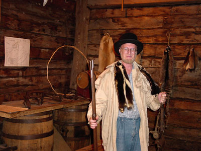
The price for getting the picture above was posing for this picture. Do I
look like a trapper coming in to trade my furs for some supplies I need?
Our next stop was the National Frontier Trails Center in Independence, MO. They have an excellent museum highlighting the westward expansion after Lewis and Clark completed their expedition. It focuses especially on the Santa Fe, Oregon, and California trials. Independence, MO was the primary jumping off spot for these trails. Over 350,000 people made their way west over these trails from about 1830 to when the transcontinental railroad was completed in 1869. It was fascinating reading excerpts from diaries and books by people who made the trip west.