Searching
for the Mountain
July 31-Aug 9, 2008
After the flight to see the bears we headed north to see Mt. McKinley.
McKinley is its official name, but it is more commonly known
by its Athabascan name, "Denali", which means "the high one";
this is certainly appropriate since it is the highest mountain (20, 320
ft) in North America. Denali is also known in Alaska simply
as "the Mountain", and people know which one you mean. Among
high mountains, it is also unique for its extreme northern latitude and
that it is 2,920 feet higher than the next nearby mountain (Mt.
Foraker) and about 8,000 ft higher than most of the mountains around it
. Consequently, it really stands out. Being so high, it makes its own
weather and is usually enshrouded by clouds; I have read that Denali is
totally visible only ten percent of the time.
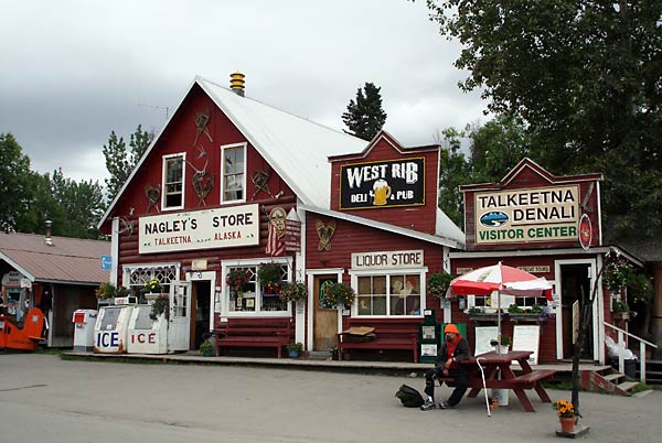
Heading north, our first stop was Talkeetna, where the mountain is
sometimes visible from a hillside viewpoint as you enter the town. But
it was not "out" when we were there. Talkeetna is an interesting Alaska
town in its own right; most of the village has been declared an
historic landmark. Some people say that Talkeetna was the inspiration
for the TV series, "Northern Exposure".
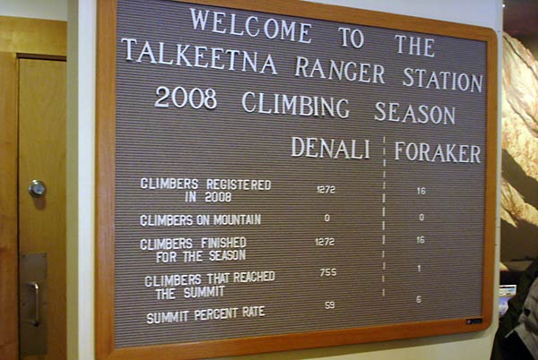
Mountain climbers headed for Denali, check in at the Talkeetna ranger
station before starting their climb. This sign in the ranger station
gave the statistics for the climbing season just finished (May and June
are best). Almost all climbers start by flying from Talkeetna to the
Kahiltna glacier at the 7,200 ft level on the side of Denali. From
there it is on foot. We learned in the ranger station that the average
climbing party takes about 3 weeks to get from the glacier to the peak
(if they make it) and back, so there are several hundred people on the
mountain at the same time. Since the climbing season is only two months
long, and you can only climb when the weather allows it, there are a
lot of people reaching the summit on the same day. Too crowded for me;
I think I'll drop the idea of climbing Denali (:-). I asked about some
statistics not shown and was told that there were about 40 serious
accidents on the mountain and four climbers died.
The sign also shows statistics for Mt. Foraker, which,
at 17,400 ft, is the second highest mountain in the area. Mt.
Foraker is considered a technically much more difficult climb. Note
that only 16 people attempted it, and only one person made it.
After Talkeetna we went to the Denali Viewpoint South in Denali State
Park; this is about 41 miles from the Mountain (as the crow flies) and
offers a good view of it, when it is out. It was not out. We spent the
night there, hoping Denali would make an appearance the next day. The
next morning we awoke to rain and dark clouds; no mountains to be seen.
We headed next for Byers Lake in Denali State Park, where we could do
some kayaking if the rain stopped. Denali is about 35 miles
from Byers Lake and is supposed to be visible from the eastern side of
the lake. After two days of rain, no kayaking, and no mountain views,
we headed north to Cantwell to stay at a private RV park, take showers,
do laundry, and have internet access.
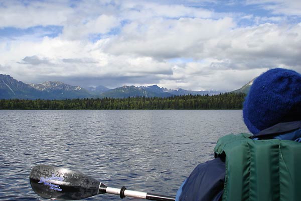
Next we headed back to Byers Lake for another shot at seeing the
mounain. The weather improved enough to do some kayaking, but still no
view of Denali.
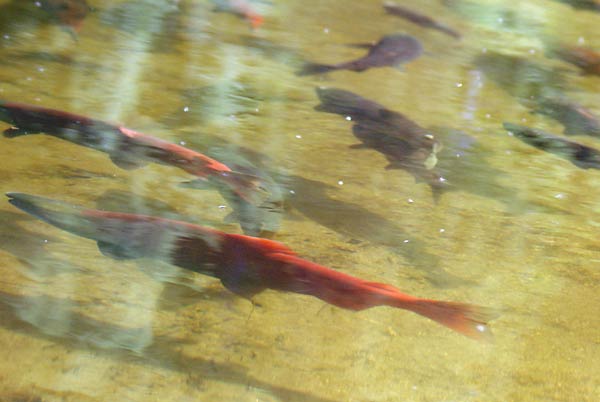
A consolation prize at Byers Lake was being able to see the sockeye
salmon run. They were congregating at the inlet to the lake and heading
upstream where we could see them spawning. Sockeye salmon, also known
as red salmon, turn a bright red when they are ready to spawn.
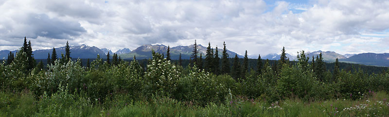
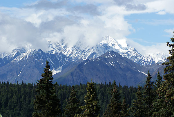
After a couple of days at Byers Lake we headed north to Denali
Viewpoint North, which is about 40 miles from Denali. This is a
three-photo panorama of the view there. The higher peaks of the Alaska
range, where Denali is, were totally obscured by clouds. The mountains
you see are about 5,000 feet high.
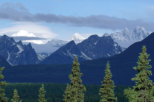
The weather was clearing, so we waited and some of the peaks of the
Alaska range came into view. The partially snow covered peak on the
right, with the totally snow covered peak behind it and further to the
right, looks similar to photos of Denali. Some people concluded that
those were indeed the south and north peaks of Denali, took pictures of
themselves in front of it, and got in their cars and drove on, pleased
that they had "seen Denali". But we waited some more.

After a while, Nancy noticed another, and much higher peak, starting to
emerge from the clouds. This is the real Denali making an
appearance, although it never really completely emerged from the
clouds. So we spent the night, hoping for a better view in the morning.
The next morning we awoke to a beautiful view of some other peaks in
the Alaska range, but no Denali.
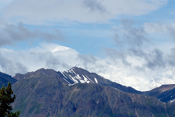
After a while, Denali put in a partial, and brief, appearance. The
peak, and part of its shoulder was visible. While we were there we
talked with some people who had just come from the Denali south
viewpoint (25 miles south); They said that, at the south viewpoint,
most of the mountain was visible, but the peak was obscured by clouds.
Also, they could see more of the mountain since it was not obscured by
the foreground mountains like happens here. So we headed south, again,
to have another chance at seeing the Mountain.
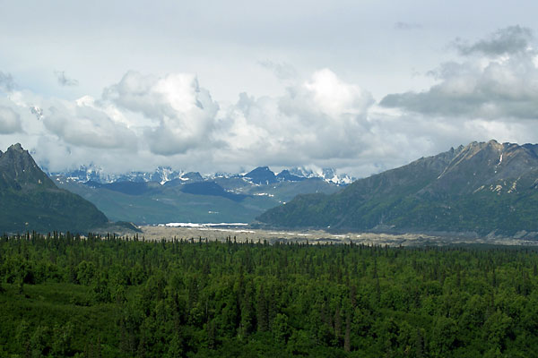
When we got to the south viewpoint, the mountain was no longer out; it
would be on the right side in this picture. Mt. Hunter (14, 573 ft) is
partially visible on the left. In the Athabascan legends, Mt. Foraker,
the second highest peak in the range, is known as Denali's wife and Mt.
Hunter, the third highest peak, is their child.
Hoping that the next day would give another chance at seeing the
Mountain, we spent the night at the south viewpoint. But, it was
raining the next day, so we headed for Denali National Park. Enough
chasing a mountain that doesn't want tobe seen.